How does it work?

The first step of the DRM workflow is conducting a reality capture campaign using 360° cameras or drone imagery to document current field conditions. The collected images (as-is) are then processed and spatially aligned with the facility’s BIM model (as-designed). Using AI-assisted analysis, the system automatically identifies inconsistencies between the designed and actual conditions, generating a structured list of divergent TAGs, 3D reliability heatmaps, and a criticality assessment of each detected deviation.
")


How does it work?

The first step of the DRM workflow is conducting a reality capture campaign using 360° cameras or drone imagery to document current field conditions. The collected images (as-is) are then processed and spatially aligned with the facility’s BIM model (as-designed). Using AI-assisted analysis, the system automatically identifies inconsistencies between the designed and actual conditions, generating a structured list of divergent TAGs, 3D reliability heatmaps, and a criticality assessment of each detected deviation.
Challenges you may be facing:
Struggling with laser scans?
Laser scanning delivers high accuracy, but it comes with trade-offs that limit its availability and scale. Acquisition requires specialized equipment and teams, making campaigns expensive and infrequent. Even when data is captured, alignment uncertainty and heavy processing slow everything down.


Precision alone doesn’t scale
Vidya’s Digital Reality Match (DRM) shifts the focus from millimetric precision to operational viability. Using field images (such as 360-degree videos and drone photos) instead of scans, DRM enables faster, lower-effort reality capture across larger areas. This makes it possible to validate asset conditions more frequently, not just occasionally.
With lighter data and automated comparison, discrepancies can be identified sooner without the overhead of point cloud processing. DRM doesn’t replace laser scanning. It ensures you don’t depend on it for everything.
Struggling with laser scans?
Laser scanning delivers high accuracy, but it comes with trade-offs that limit its availability and scale. Acquisition requires specialized equipment and teams, making campaigns expensive and infrequent. Even when data is captured, alignment uncertainty and heavy processing slow everything down.
Precision alone doesn’t scale
Vidya’s Digital Reality Match (DRM) shifts the focus from millimetric precision to operational viability. Using field images (such as 360-degree videos and drone photos) instead of scans, DRM enables faster, lower-effort reality capture across larger areas. This makes it possible to validate asset conditions more frequently, not just occasionally.
With lighter data and automated comparison, discrepancies can be identified sooner without the overhead of point cloud processing. DRM doesn’t replace laser scanning. It ensures you don’t depend on it for everything.


When Digital Reality Match is a must
When Digital Reality Match is a must
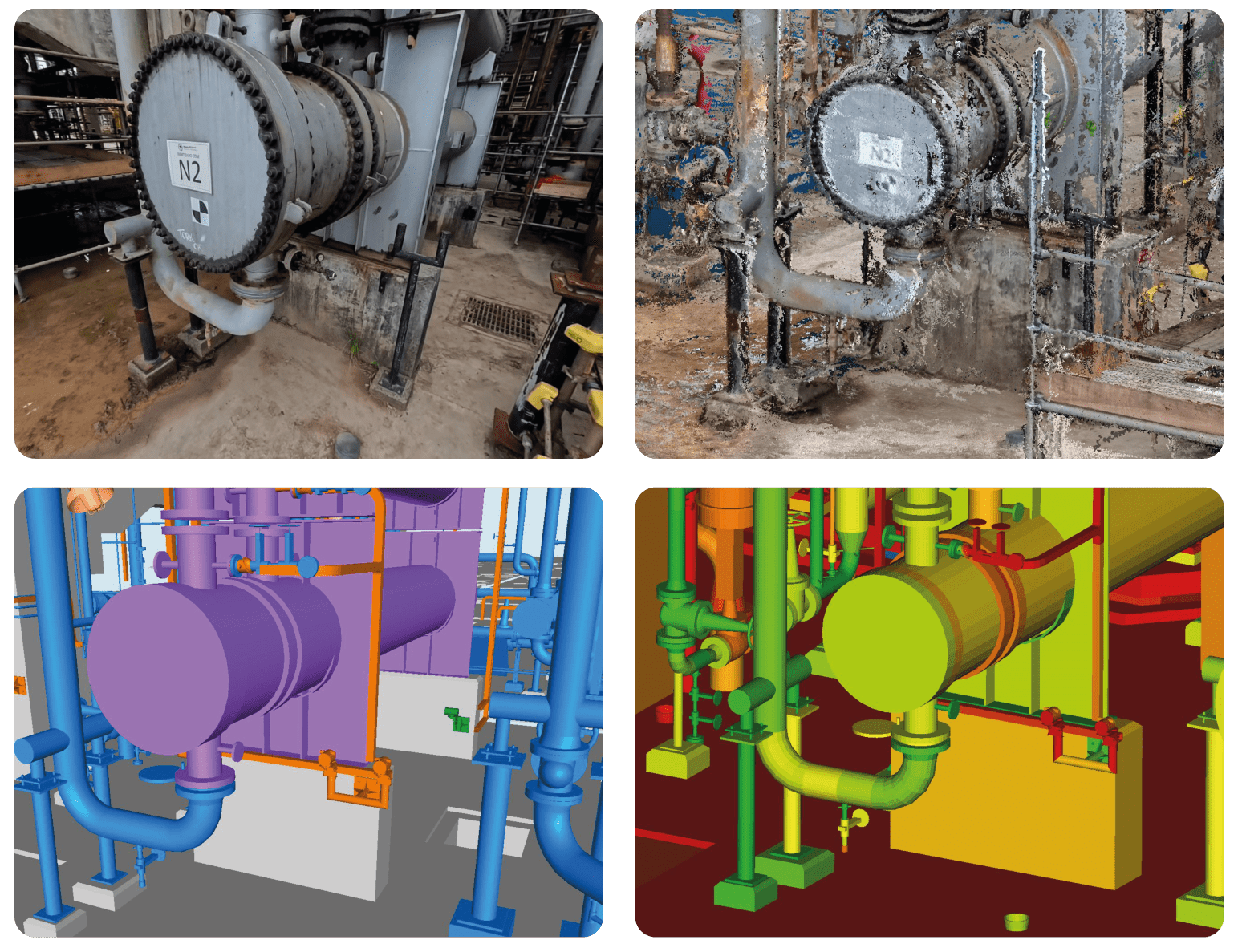
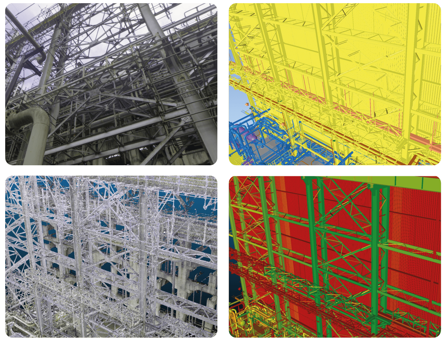
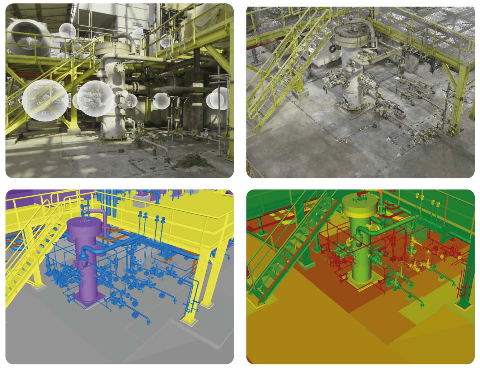
Example of a Digital Reality Match (DRM) Post-processing
The upper-left image shows the reality capture output. The upper-right image displays the point cloud generated by our pipeline. The lower-left image is the legacy CAD 3D model, while the lower-right shows the same model with a heatmap indicating the confidence level of field discrepancies. Elements highlighted in red represent areas where the AI identified divergences between the model and the captured reality.
See Digital Reality Match in action
Schedule a Demo & Experience the benefits. Start with a focused scope and expand based on your needs.
Beyond a digital solution, we help you operate with ease without requiring a large upfront commitment. By scheduling a meeting, we will: